![]()
![]()
![]()
Lancée par Île-de-France Mobilités en avril 2024, Transport Public Paris 2024 est « l'application officielle pour se déplacer pendant les Jeux olympiques ». Elle permettra notamment d'utiliser son smartphone (iPhone ou Android) pour valider son titre de transport dans le métro.
![]()
![]()
![]()
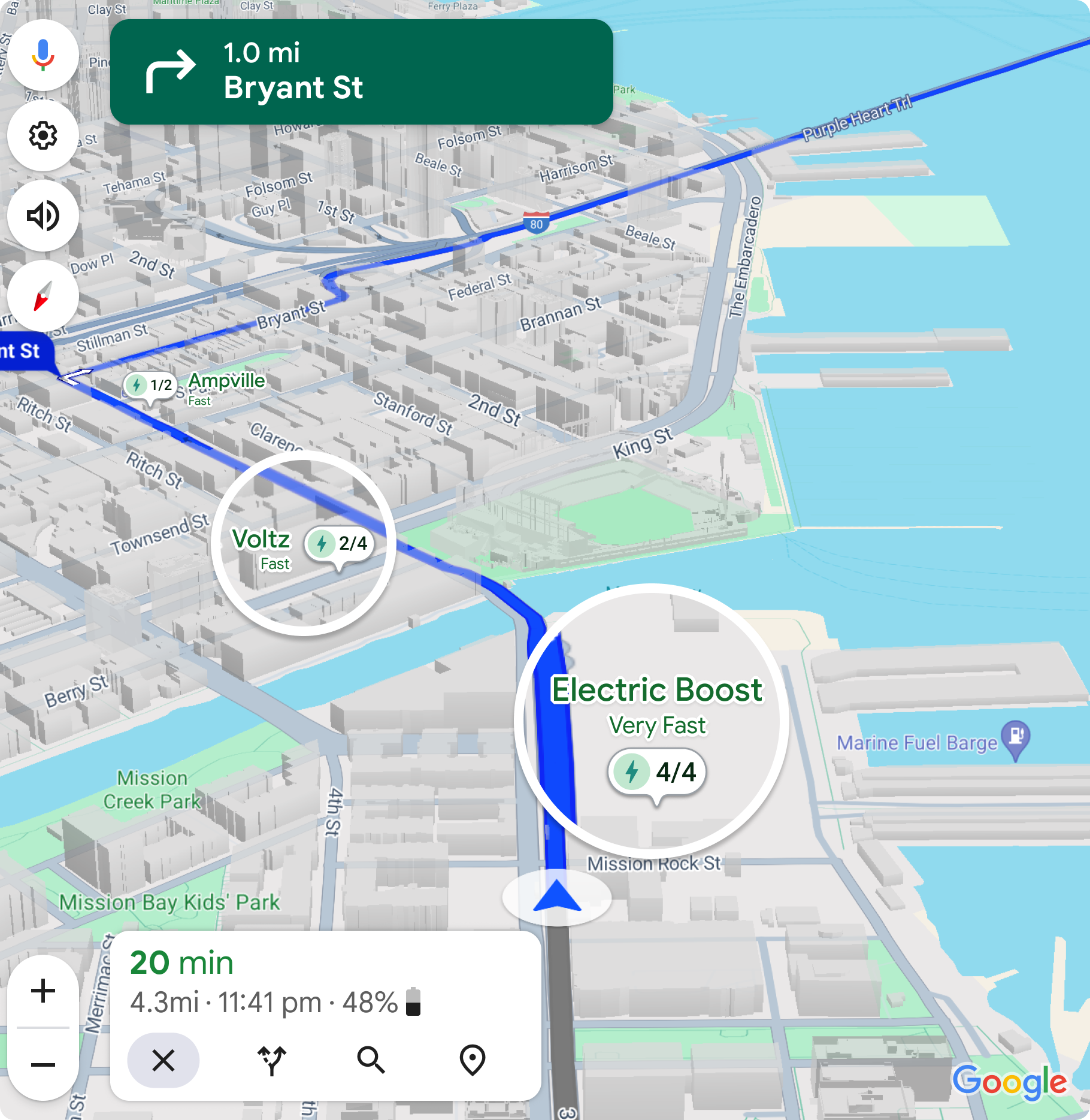
Enlarge / EV charger status is coming to Google Maps. (credit: Google)
Google Maps is making itself friendlier for electric vehicles. A couple of years ago it added the option to select different powertrain types when calculating a route—gas, hybrid, electric, and so on. Lower-energy routes with fewer hills are helpful for electric vehicles, but mostly what EV drivers on unfamiliar terrain really want to know about are the chargers: Where are they, how fast are they, and do they work? Soon, that critical information will be available to Google Maps users via a new update.
Live charger status is usually available from the onboard navigation system built into an EV. Better yet, those native nav systems invariably talk to the powertrain, so they know how much state of charge is currently in the battery and how much to expect upon arrival. Add in real-time status on chargers—how many are working, how many are available—and it's not hard to see why plenty of EV drivers stick with the built-in system.
But for some EVs, that built-in system is Google Maps, including EVs from Ford, Honda, General Motors, Volvo, Polestar, and soon even Porsche. These will be the first devices to receive the update, Google says, which will roll out globally in the coming months. After the connected cars, smartphones will be next.
![]()
![]()
![]()
![]()
![]()
![]()
![]()
![]()
Google Maps ne reviendra pas dans la recherche de Google. En tout cas, pas sous la version qui prévalait depuis des années. Ce qu'il reste de Maps pour l'Union européenne est une version fortement diminuée, qui prend la forme d'une simple image statique. C'est l'arrivée du DMA qui a poussé Google à castrer Maps dans la recherche.
![]()
![]()
![]()
Le fonctionnement de Maps dans Google est fortement altéré, en raison du Digital Markets Act (DMA), un règlement européen qui entre en vigueur le 6 mars 2024. Mais il est possible d'associer de nouveau la cartographie au moteur de recherche, pour l'utiliser directement dans les résultats.
![]()
![]()
En Australie, deux touristes allemands ont suivi aveuglément l'itinéraire suggéré par Google Maps. L'application les a envoyés sur un chemin de terre où ils se sont enlisés. Ils ont alors dû chercher les secours à pied en s'efforçant d'éviter les dangers de la faune environnante.
L’article Google Maps : ils se retrouvent au milieu des crocodiles à cause de l’application est apparu en premier sur Toms Guide.
google-maps
![]()
full
google-maps
![]()
thumbnail
![]()
![]()
![]()
![]()
![]()
![]()
![]()
![]()
![]()
![]()
![]()
Une petite phrase prononcée par le patron d'IDF Mobilités a suggéré la possibilité de faire fermer Google Maps et Citymapper durant les Jeux Olympiques de Paris. En réalité, il est surtout demandé aux deux applications mobiles de jouer le jeu et de se coordonner avec l'autorité organisatrice des transports pour fluidifier au mieux le trafic.
![]()
![]()
À Las Vegas, la startup française Exwayz a proposé à Numerama de monter dans une voiture équipée de deux capteurs LiDAR, afin de nous montrer comment elle modélisait un environnement en 3D. Exwayz commercialise un logiciel pour les entreprises qui veulent fabriquer leurs propres véhicules autonomes.
![]()
![]()
![]()
Google a commencé à ajouter une nouvelle fonctionnalité à son application Maps : la possibilité de visualiser une carte en 3D pendant la navigation.
![]()
![]()
Enlarge / Girl with an ecstasy tablet on her tongue. (credit: Getty | UniversalImagesGroup)
A corporation dedicated to studying the benefits of psychedelic drugs filed an application with the Food and Drug Administration this week for approval to use MDMA—aka ecstasy or molly—in combination with talk therapy to treat post-traumatic stress disorder.
If approved, it would be the first-of-its-kind combination treatment—a psychedelic-assisted therapy. An approval would also require the Drug Enforcement Administration to reclassify MDMA, which is currently in the DEA's most restricted category, Schedule I, which is defined as drugs "with no currently accepted medical use and a high potential for abuse." The category also includes LSD, heroin, and marijuana.
The public benefit corporation (PBC) that filed the FDA application was created by MAPS, The Multidisciplinary Association for Psychedelic Studies, which has been supporting this type of work since 1986. The application is based on positive data from two randomized, double-blind, placebo-controlled Phase III studies, which were funded and organized by MAPS and MAPS PBC.
Google announced big changes to its most legally fraught set of user settings: your location data. Google's misleading Location History descriptions in Google Maps have earned it several lawsuits in the US and worldwide. A quick count involves individual lawsuits in California, Arizona, Washington, a joint lawsuit in Texas, Indiana, and the District of Columbia, and another joint lawsuit across 40 additional US states. Internationally, Google has also been sued in Australia over its location settings. The point is that any change to Google's location settings must have some motive behind it, so bear with us while we try to decode everything.
Google's big new location data change is a new, duplicate data store that will live exclusively on your device. Google's new blog post says data for the long-running Google Maps Timeline feature will now "be saved right on your device—giving you even more control over your data." That's right, one of the world's biggest Internet data companies advocates for local storage of your location data.
The company continues, "If you’re getting a new phone or are worried about losing your existing one, you can always choose to back up your data to the cloud so it doesn’t get lost. We’ll automatically encrypt your backed-up data so no one can read it, including Google." Users will apparently have lots of control over this new locally stored data, with Google saying, "Soon, you’ll be able to see all your recent activity on Maps... in one central place, and easily delete your searches, directions, visits, and shares with just a few taps. The ability to delete place-related activity from Maps starts rolling out on Android and iOS in the coming weeks."
![]()
![]()
Google Maps vous permet depuis belle lurette d'enregistrer l'endroit où vous êtes stationné pour retrouver facilement votre véhicule plus tard. Bonne nouvelle, cette fonctionnalité très pratique vient tout juste de s'inviter sur la version Android Auto de l'application de navigation.
L’article Android Auto : Google Maps peut vous aider à retrouver votre place de parking est apparu en premier sur Toms Guide.
android-auto-parking-place
![]()
full
android-auto-parking-place
![]()
thumbnail
![]()
![]()
Difficile de faire l'unanimité, surtout pour un service utilisé par des millions de personnes dans le monde. Le changement de la palette de couleurs dans Google Maps provoque bien des réactions courroucées, beaucoup comparant l'application à Apple Plans. Tout ce qu'il ne fallait pas faire !
La nouvelle palette de couleurs de Google Maps ne plait pas à tout le monde
![]()