Connexion


Part II of the celestial Travelogue through the western regions of China.
By Silk Road pilgrim Pepe Escobar on the Strategic Culture Foundation.

DUNHUANG – Across History, the Silk Road – actually a network of roads – is the supreme Highway Star: the most important connectivity corridor ever, rolling across Ancient Eurasia, linking what Chinese scholars consensually define as the main civilization systems in the world: China, India, Persia, Babylon, Egypt, Greece and Rome, as well as showcasing several historical stages of economic and cultural exchanges between East and West.
Prof. Ji Xianlin, a top scholar of Dunhuang Studies, came up with a formulation certified to drive Western supremacists crazy for all eternity:
“There are only four, rather than five, influential cultural systems in the world: Chinese, Indian, Greek and Islam. They all met only on China’s Dunhuang and Xinjiang”.
Dunhuang’s prime geo-strategic position across History was inevitably bound to generate spectacular artistic achievements.
After years since my previous journeys, then the Covid shock, then China’s subsequent recovery, I have been privileged to finally embark on a renewed Journey to the West to retrace the original Ancient Silk Road, starting in Xian – the former imperial capital Chang’an – all the way through the Gansu corridor to Dunhuang.
Brilliant Eurasian cultures converged, interacted and spread their wings on the Ancient Silk Roads. Dunhuang – on the western end of the Hexi corridor in Gansu province – was the most vital hub in the eastern section of the Chinese Silk Road, framed by mountains to the north and south, the central plains to the east, and Xinjiang to the west.
Dunhuang, the “Blazing Beacon”, held a supremely strategic position controlling two passes – Yangguan and Yumenguan. Han Emperor Wu Di clearly understood that Dunhuang was the last major water source before the fear-inducing Taklamakan desert to the west, as well as sitting astride the three main Silk Road routes heading west.
Yumenguan was the all-important Jade Gate pass – set by the Han empire in the 2nd century B.C.: placed in the south Gobi and the western end of the Qilian mountains, actually marking the western limit of classic China.
(L): The remains of the Great Han Wall ; (R): Xian
I spent a whole blinding beautiful blue-sky day in the pass and its surroundings after striking a deal with a taxi driver in Dunhuang. It’s a thrill to admire how the Han dynasty organized their traffic management system, the beacon fire system, and the Great Wall defense system (remains of the Han Wall are still there) – guaranteeing the safety of the long-distance Silk Road connectivity corridor.
Talk to the caravan: the secret of “people to people’s exchanges”
At the impeccably organized Dunhuang Book Center, historical records refer to it as “a metropolis where the Han people and non-Han peoples meet”. Quite the antecessor to Xi Jinping’s “people to people’s exchanges.” The spirit remains, especially at the fabulous Night Market, a gastronomic feast with pride of place for Uyghur recipes.
Silk and porcelain from the central plains, jewelry and perfume from “the western regions”, camels and horses from north China, grains from Hexi, everything was traded in Dunhuang. Merchant deals, migrations, military games, cultural exchanges, a profusion of literati, scholars, artists, officials, diplomats, religious pilgrims, military brought classic Chinese culture into an effervescent mix – Sogdian, Tibet, Uyghur, Tangut, Mongolia – all absorbed into what eventually became Dunhuang art.
(L): Uyghur businesswomen at the fabulous Dunhuang Night Market ; (R): The Desert Princess look. Affordable. Less than $60 for a set of clothes, make-up, 25 exclusive pics and retouches.
Itinerant Buddhism, Nestorianism, Zoroastrianism, Islam – the sophisticated aesthetic feel of Dunhuang was progressively influenced by architecture, sculpture, paintings, music, dance, weaving, dyeing techniques all the way from Central Asia and West Asia.
“Silk Road” terminology in Xi’s “moderately prosperous” modernized China is an extremely nuanced business. For instance, already in Xian, at the Small White Goose pagoda, we see it described as “Silk Roads: The Routes Network of Chang’an-Tian Shan corridor”.
Xian. (L): The perfect lamian at the Muslim Quarter – since Tang times ; (R): DON’T mess with a Tang warrior princess
That’s a geographically correct interpretation, stressing the Tian Shan mountains instead of the politically correct Xinjiang (which was essentially part of the “western regions”, not necessarily Chinese territory, for centuries).
As for how the Silk Road began, that now follows a single, scholarly accepted version: Han Emperor Wu Di, in 140 B.C. sent Zhang Qian as an envoy to the “western regions” on two business missions. The “Records of the Grand Historian” show that Zhang Qian, as the first official diplomat in Chinese history, de facto opened channels of communications with the “western regions” and then all the states in the northwest started trading with the Han, especially silk.
(L): On the road to the Jade Gate Pass. Electrification ; (R): At the Dunhuang Academy museum: where the artists came from
From Xian’s Shaanxi History Museum to the Dunhuang Academy, and including the Gansu museum in Lanzhou, in interactions with scholars and museum curators as well as in complement to formidable Silk Road exhibits, it’s fascinating to retrace the now established official narrative on the Silk Roads, according to which “the civilization of ancient China represented by silk started to impact the states in the western regions, Central Asia and West Asia.”
It was way more complex than that – as spices, metals, chemicals, saddles, leather products, glass, paper (invented in the 2nd century B.C.), everything was on the market, but the general drift applies: merchants from the central plains defying deserts and mountain peaks in caravans laden with silk, bronze mirrors and lacquerware from China, seeking to exchange them for commodities, while merchants from the western regions brought furs, jade, felts to the central plains.
Talk about multi-ethnic “people to people’s exchanges”. And by the way, no one ever used the term “Silk Road”; it was “the road to Samarkand” or just the “northern” or “southern” routes around the ominous Taklamakan desert.
About the Tang dynasty monetary system…
By the 3rd century, Dunhuang was already at the apex of Silk Road connectivity; and that’s when merchants and pilgrims started to sponsor the construction of the nearby Buddhist Mogao caves.
The Mogao Caves are part of what is known in Gansu province as the five Dunhuang grottoes. It’s the same system of caves – 813 surviving, with 735 in Mogao. To approach Mogao is a major thrill in itself: we need to be in an official park bus, crammed with zillions of Chinese tourists, rolling through the desert, and suddenly we are in the eastern foot of the Mingsha mountains, with the Dangquan river running right in front of us, facing the Qilian mountains to the east, with the caves set back against and cut into the cliff face, connected by a series of ramps and walkways.
the Mogao caves (L): the main pavilion ; (R): One of the Buddha highlights
The caves started to be built as early as in the 4th century – all the way to the 14th century (the earliest wall paintings are from the 5th); it’s a group of caves in four levels, 1,6 km from north to south along a cliff as much as 30 meters high. The 492 caves in the southern area house more than 45 km of wall paintings, over 2,000 painted statues, and five wooden eaves. They were originally used for worshipping Buddhas.
What we are still able to see takes our breath away. Highlights include a wrestling scene from Buddha’s life on cave 290; a girl apsara – mythic dancer – on cave 296; the Deer King on cave 257; a hunting scene on cave 249; a Garuda – defined in Chinese as “the Scarlet Bird” – on cave 285; parables of the Magic City from the Lotus Sutra, a masterpiece of High Tang dynasty, on cave 217; a sitting Boddhisattva on cave 196; impeccably preserved worshipping bodhisattvas on cave 285.
Rules are extremely strict: visit only to selected caves, with an official guide, no photos, only the guide’s torchlight to illuminate the grottoes. I was privileged to visit guided by Helen, who studied in Dunhuang University and is now doing her PhD in Archeology. After the visit she explained in detail the ground-breaking conservation work of the Dunhuang Academy.
The construction of the caves was a spectacular undertaking in terms of division of labor. Just imagine: chiselers to dig and excavate a cave out of the cliff; stonecutters, who also dug caves; bricklayers to build wooden or earthen structures; carpenters, who also repaired wooden tools; sculptors to create the statues; and painters to paint the caves and statues.
Mogao, as an aesthetic experience, is unequaled in its striking collection of Buddhist wall painting criss-crossing China, Persia, India and Central Asian art.
And then there’s what we cannot see: more than 40,000 scrolls found in the library cave, the largest deposit of documents and artifacts discovered anywhere along the Silk Road, with texts on Buddhism, Manicheism, Zoroastrianism and the Eastern Christian Church (from Syria) showing how cosmopolitan Dunhuang was. That’s part of the European scholarly – and otherwise – plunder of the Dunhuang wealth starting in the late 19th century, a completely different, complex, and long, story.
Kashgar. A big fan of the lemonade drink Baksap found everywhere in Xinjiang
In geoeconomic terms, for nearly ten centuries Dunhuang was extremely wealthy, especially during the Tang dynasty (6th to 9th century). The Tang had a fascinating monetary system – with three different currencies: textiles (silk and hemp), grain and coins.
The central government, in the imperial capital Chang’an, used a single aggregate unit to represent all trade. The Dunhuang garrison was a key strategic post: payments came in no less than six different types of woven silk. Well, each place paid their taxes with their locally produced cloth. What the Tang did was to transfer all these textiles to Dunhuang. The garrison’s officers then converted the tax cloth into coins and into grain, to pay local merchants and to feed the soldiers.
So in a nutshell the Tang dynasty was all the time injecting a lot of money – via woven cloth – into the Dunhuang economy. Talk about a public-private state development model – which certainly did not escape Beijing planners when they came up, in 2013, with the concept of the New Silk Roads.
ADDENDUM
≈≈≈
A celestial Travelogue through the western regions of China.
By Silk Road pilgrim Pepe Escobar on Sputnik.
ON THE ROAD IN XINJIANG – Xuanzang, the itinerant Buddhist monk, has got to be one of the most extraordinary figures in History. He certainly is regarded as such in China.
In the early Tang dynasty in the 7th century, Xuanzang set out from the imperial capital Chang’an (today’s Xian), breaching a veto to travel to the “Western regions”, to go to India to fetch Buddhist manuscripts that he planned to translate into Chinese.
(L): The one and only Yumenguan – the Jade Gate Pass, marking the western limits of China for centuries. ; (R): Xinjiang. Flying over the Tian Shan mountains.
He crossed the Jade Gate Pass; kept walking further West; almost died of thirst in the desert; crossed the snow peaks of the Tian Shan mountains on horseback to Transoxiana; and finally reached India, where he studied for several years before returning to Chang’an 15 years after his departure with 22 horses loaded with Buddhist manuscripts in Sanskrit, plus religious relics and priceless Buddha images.
That’s my kind of guy. Since the late 1990s, I have followed on Xuanzang’s footsteps, on and off, along several stretches of the Ancient Silk Roads. Xuanzang was fictionally reincarnated in a magic-tinged 16th century novel which became quite popular in China, titled Xiyouji, or Journey to the West. That’s exactly what I set out to do – a compact Journey to the West for the digital era – this past month of September.
Sericulture was developed as early as 5,000 years ago in the Yellow River – in China’s historically traditional heartland. It spread out to Korea and Japan but mostly traveled West, along the larger-than-life Silk Road(s).
The start of the silky story is shrouded in historical mist. It is widely accepted in China that under the reign of Emperor Wu Di, in the second century B.C., special envoy Zhang Qian was twice dispatched to the “vast regions” to the West of China on a business mission.
At the glorious Shaanxi History Museum in Xian. (L): Drop-dead chic Tang Barbie, where I had a fab Silk Roads conversation with one of the curators ; (R): Silk Road golden splendour
Soon after, cross-border trade entered a new stage, with silk fabric among the key exports. Thus Zhang Qian was officially credited as the opener of the Silk Road – and granted the title of Duke. Today, at the fabulous Shaanxi History Museum in Xian, his exploits and the subsequent development of the Silk Road connectivity corridors are detailed alongside a mesmerizing collection of Silk Road artifacts.
Xian. (L): TikTok Tang Barbies on a roll. ; (R): Happiness is a bowl of perfect lamian in the Muslim Quarter
The Silk Road, actually a maze of roads, started in Chang’an, the old imperial capital, today’s Xian. Then it headed west through the spectacular gorges of the Wei river to the garrison city of Lanzhou, at the eastern end of the Hexi corridor. North is the Gobi desert; south is the snow-covered peaks of the Qilain Shan. The road keeps going from oasis to oasis all the way to Yumenguan, the Jade Gate Pass – which marked the western limit of China.
Lanzhou. (L): Downtown: dancin’ in the streets ; (R): The Flying Horse of Gansu: the epitome of Chinese bronze craftmanship
For a Silk Road pilgrim like this foreign correspondent, this is the trip of a lifetime – combined with the journey further west, to Xinjiang. I’ve tracked the original Silk Road before, and that’s my fifth time in Xinjiang; yet those journeys were in the late 1990s and the 2000s. Combined, now, that makes it the first trip in 10 years and the first one after Covid.
New Silk Roads on the move. At the fabulous Gansu museum in Lanzhou
Go West, past the Jade Gate Pass
The timing could not be more appropriate: right after the ground-breaking SCO summit in Tianjin in late August/early September and the Victory Day parade in Beijing on October 3, celebrating the 80th year of the Chinese defeat of Japanese aggression and Nazi-fascism in Asia.
It was the time to check in detail how a self-confident China had engineered its development of the West, boosted by the “Go West” campaign launched in 1999. That also coincided with the 70th year of the establishment of the Xinjiang Uyghur Autonomous Region. The whole of Xinjiang was engulfed in “70” red flags.
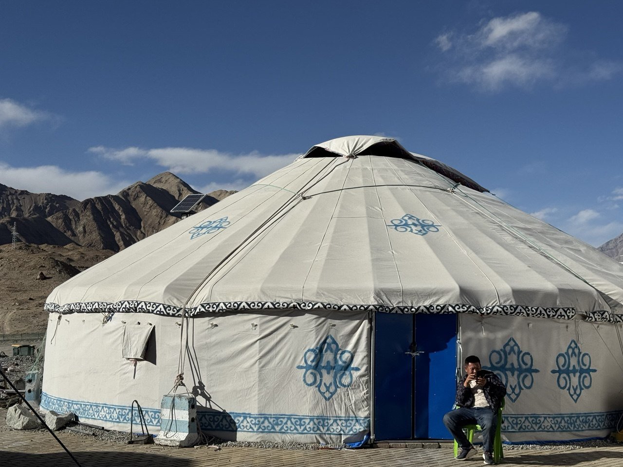
Xinjiang. (L): Yurt time ; (R): The ancient city of Jiaohe
Xinjiang. (L): On the Northern Silk Road, from Aksu to Kucha ; (R): Northern Silk Road. Cotton fields. No slaves. No victims of “genocide”
The first stretch of my travels was solo, retracing the traditional Ancient Silk Road, from Xian to strategically located Lanzhou by the Yellow River, dominating all traffic between central China and the northwest, then all the way to fabled Dunhuang and the Jade Gate Pass. I made a deal with a local taxi driver to spend the day visiting the Pass, including the remains of the Han Great Wall. He loved the notion of a lone foreigner riding his taxi into the deep desert.
Then I caught the high-speed train from Lanzhou to Urumqi (this line was started already 11 years ago), the high-tech capital of Xinjiang, to join a Chinese-Uyghur production team and start shooting a documentary on the road in Xinjiang.
Xinjiang, or “New Territories”, the size of Western Europe, is the former Chinese Turkestan. That’s classic Silk Road territory as well, treading along the northern and southern rims of the Tarim basin, one of the most extraordinary geographical hot spots on earth. At the center lie the ever-shifting sands of the mighty Taklamakan desert – surrounded by three mountain ranges: the Kunlun Shan, the Tian Shan and the Pamirs.
We started by following the Northern Silk Road, from the key oasis of Turfan to the high-tech hub Urumqi, all the way to Kucha; crossed the Taklamakan desert to the Southern Silk Road; and proceeded across key oasis such as Yutian and Khotan all the way to the immensely venerable oasis of Kashgar, at the foot of the Tian Shan and the Pamir, and at the start of the Karakoram highway, arguably the pivot of the Ancient Silk Road leading to the heart of the Heartland: southern Central Asia.
Countless caravans perished over centuries in the sands of the Taklamakan (“you can get it but you won’t get out”): today, modernization of China-style, we can do it in an immaculate highway in a mini-convoy of Toyota Land Cruisers. [01][02][03]
We kept going via the Karakoram, a two-lane, extra-busy, connectivity corridor, the first stretch of the China-Pakistan Economic Corridor (CPEC), past the blinding beauty of glaciers, peaks and deep blue lakes all the way to Pamir lands and the high-altitude Tajik boom town of Tashkurgan; further on is the Khunjerab pass and the China-Pakistan border, all the way to South Asia.
To the west, the main historical Silk Road is subdivided in the three, key Chinese borders with Tajikistan, Kyrgyzstan and especially Kazakhstan: Alashankou in northern Xinjiang is China’s premier Eurasian hub – where all trains carrying laptops from Chongqin or household wares from Yiwu stop before heading further West, all the way to Europe.
(L): Khotan. In the – Carpet – Silk Road ; (R): On the road to Pamir land
Socialism with Chinese characteristics in practice
China has always been a Heartland power – not a maritime power. From the time of unification under Qin Shi Huang in 221 B.C., the territorial imperative has always been Go West, towards the Heartland/Southern Central Asia. That set up a series of intermittent clashes with primarily nomadic peoples – Turkic, Tibetan, Mongols. Only at times of serious Chinese strength – especially under the Han, Tang and Qin dynasties – Chinese imperial power was conclusively projected into Western Central Asia.
What we see now in a Xi Jinping-defined “moderately prosperous China”, inscribed within the mindset of a self-confident geoeconomic superpower, is how socialism with Chinese characteristics has successfully integrated the “Western regions” into the officially-termed “Chinese dream”.
Xinjiang. (L): Urumqi – symbol of the development of the “Western regions” ; (R): Kashgar. In the Old City, in front of Id Kah mosque
Urumqi is now a high-tech hub, a replica of those mega-cities in the eastern seaboard but 4,000 km away from Beijing. With over 4 million residents, it’s considered at best a Tier 3 city. The level of development compared to the start of the century is simply mind-boggling.
Xinjiang. (L): Urumqi on Saturday night – buildings celebrating the 70th year of the development of Xinjiang under a unified China. Xi will be in town today ; (R): On the Northern Silk Road. Stan and I at the spectacular Grand Canyon near Aksu.
We traveled in Xinjiang with a crack Uyghur team. Our on-site producers, translators, ultra-skilled drivers were all Uyghurs. We talked to everyone – from cotton pickers to bazaar whiz kids to enterprising business women (no, we did not find “genocide” victims). We attended two traditional weddings – one relatively low-key, the other a Bollywood-style production.
As @RealPepeEscobar, @RealJermWarfare and I checked into the hotel in Turpan, Xinjiang, we crashed a Uyghur wedding party (after asking for permission to film).
Absolute highlight of our evening! Uyghur wedding is the next level!!! pic.twitter.com/0Al52W8du8
— Carl Zha (@CarlZha) September 20, 2025
(L): With the ultra-pro Tajik MC of a lively dancin’ party ; (R): Kashgar princess
In parallel, a tsunami of middle-class families from all over China could be seen in every latitude enjoying Xinjiang for the first time in a self-driven Tank 300 jeep rented for only $60 a day (less than 1 in 10 Chinese have been to Xinjiang). The boom of domestic tourism is something to watch – as in the packed camel parking lot right before whole families immortalize their camel caravan adventure in the sand dunes outside Dunhuang. The Old City in Kashgar during Golden Week – an 8-day holiday that every Chinese dreams about – was so packed it was virtually impossible to walk most of the time in the main alleys.
This is just a first approach to the trip of a lifetime – which will be part of a book on the Ancient and New Silk Roads to be published next year and a documentary to be released before the end of 2025 (we have two terabytes of images). But among a wealth of highlights, a few have got to be inescapable.
Energy. Xinjiang is an energy Mecca. From Urumqi to Turfan [04], from the point of view of the proverbial impeccable highway, we see Massive Electrification, forests of solar panels, forests of wind turbines, and at least two massive solar farms. Xinjiang produces so much energy that it lavishly exports to the rest of China. And of course the key Pipelineistan superstars – from Turkmenistan, Kazakhstan and soon Power of Siberia – all arrive here.
(L): Xian. At the Great Mosque. Having a fabulous time with the Hui. There are only 20k still living in Xian ; (R): Welcome to Xinjiang. At the astonishing 5th century ruins of Buddhist Gaochang kingdom
Integration of Hui (Chinese Muslims). Xian’s fabled Muslim quarter, quite close to the iconic Drum Tower, is a direct connectivity corridor to the former imperial capital’s Silk Road prominence. Itinerant Muslim merchants – Arabs, Turks, Sogdians, Persians – and religious teachers chose to live in the tolerant metropolis ever since the Tang dynasty. In the 8th century, Xian was the largest and most sophisticated city on the planet. Today at least 50,000 Huis – mostly prosperous bazaaris – live in Xian’s Old City. [05] The food in the Muslim quarter of course is to die for.
XINJIANG. Karakoram Highway. BRI/CPEC connectivity corridor. White Sand lake – on the way to Pamir lands
From oasis life to deep blue mountain lakes
Respect for History – The Shaanxi History Museum in Xian and the Gansu Provincial Museum in Lanzhou, side by side, offer an unparalleled collection of absolutely priceless Silk Road artifacts. Both are free, packed at all times and endlessly fascinating throngs of the TikTok/Bilibili generation with immense Silk Road cultural wealth, including the iconic Flying Horse of Gansu: excavated in 1969 in Wuwei, representing the “heavenly steed” of Heartland tradition and cast by an unknown craftsman of the early Han dynasty no less than 2,000 years ago. That’s arguably the most elegant and sophisticated Chinese bronze artifact ever.
Dunhuang. (L): The All China Camel Caravan is on the move ; (R): The unparalleled beauty of the remaining Buddhist paintings in the Mogao caves
Dunhuang. A “Blazing Beacon” since the times of Han emperor Wu Di, who understood the strategic importance of the oasis: the last major watering hole before the fear-inducing Taklamakan, and sitting astride the three main Silk Roads heading west, linked to the key Jade Gate Pass nearby (that refers to the fine jade brought to China from Khotan in Xinjiang).
Yet Dunhuang’s claim to a selected global cultural pantheon resides in the Buddhist Mogao caves, sponsored by merchants and pilgrims since the 3rd century and especially during the Tang dynasty, cut into the soft rock face of the Mingsha hills. [06] That’s China’s – and the world’s – most extensive collection of Buddhist statuary, painting and manuscripts. Unfortunately, many of the original materials were stolen by European barbarians, scholarly and otherwise, and are now in foreign museums. Beijing cares for the Mogao in millimetric detail. We can only visit with a scholar/guide; no photos whatsoever; and the only light inside the caves comes from the guide’s torch. A magical experience. I was privileged to enjoy a detailed explanation of Mogao history by Helen, a member of the remarkable Dunhuang Academy who’s doing a PhD in Archeology.
(L): At the Bezeklik Buddhist – and Manichean – caves, outside of the privileged oasis of Turfan. Classic Silk Road ; (R): Yutian. Carl Zha: [Pepe’s] holding up a $10,000 USD Hotan jade bracelet
Across the Southern Silk Road, we can literally touch and feel the essence of its allure: the best jade from both Khotan and Yutian (Marco Polo visited in the 13th century); the best silk and the best silk carpets in Khotan; and the best decorated knives in Yengisar – the knife capital of the world (every Uyghur man has a knife, to prove his manhood and to slice melons at any time).
And then there’s the mystery of ridiculously delicious Uyghur cuisine. No mystery: crystal clear water from the Tian Shan mountains; uncontaminated soil; lots of sunshine; everything organic; less than zero GMOs. Now get down and celebrate devouring a whole lamb.
In the heart of the Taklamakan desert. (L): the pilgrim finally made it ; (R): The fierce beauty of the Taklamakan
Crossing the Taklamakan – The Holy Grail of every Silk Road explorer. Today, no need to be engulfed by mellifluous shifting sands or unexpected sandstorms. We drove the Desert Highway back-to-back, nearly 500 km: impeccable tarmac; the notorious green belt encircling the desert on both extremities; the reeds compounding the “Chinese magic cube” by the side of the road, protecting it from the sands; plus an extra green fence.
Overall, a marvel of engineering and environmental protection. And we doubled down the day after, driving a backbreaking 170 km across the real shifting sands to see something stunning: the ancient small village of Daliyabuyi, right in the middle of the Taklamakan, arguably the most remote place in Xinjiang. The locals, known in China as “the lost tribe of the Taklamakan” are now getting into serious business: they showed us how they are building a few, comfortable B&Bs to cater for the budding Chinese off-road crowd. We crossed some of them in the sands. No wifi – yet.
(L): Xinjiang meets Pamir lands. The Muztagh Ata blesses the Karakoram highway ; (R): Lake Karakul
The Pamir lands – One of the top blinding beauty lands on earth – to be rivalled only by the Pamir highway and selected spots in the Tian Shan, the Karakoram in northern Pakistan, the Hindu Kush in Afghanistan and the Himalayas. You drive by the proverbial impeccable highway and you have the mighty Muztagh Ata (7,500 m high) practically in front of you. Lake Karakul, at 3,900 m high, is unparalleled in its blue, transparent tranquility. We can see no less than 14 different glaciers from the lakeshore. Cool Kyrgyz nomad cowboys hang out nearby; you can ride their yaks or stay in their yurts. [07] Further on down the road is Tashkurgan, mentioned by Ptolemy in the 2ⁿᵈ century as the westernmost point of the “Land of Ceres” – that is, China. Xuanzang was here in the 7th century, when he was already laden with the Buddhist sutras he carried from India to Xian.
From Xinjiang, the real challenge is to take the G216: 816 km in ultra-high altitude, considered the most dangerous road in China, all the way to Tibet. Talk about total integration of the Western regions. Well, sounds like a plan for 2026. The Silk Roads go on forever.
Le chef de Roscosmos, Dmitri Bakanov, a conclu un accord avec le chef par intérim de l’Administration nationale de l’aéronautique
L’article Bakanov de Roscosmos et Duffy de la NASA prolongent l’exploitation de l’ISS jusqu’en 2028 est apparu en premier sur STRATPOL.
“Either the U.S. lets Iran become nuclear, or the U.S. has to engage diplomatically.”
In this interview, Negar Razavi speaks with @vali_nasr about his new book, Iran’s Grand Strategy: A Political History — and the choices ahead for U.S. foreign policy.
It was pleasure to speak with Security in Context on my book Iran’s Grand Strategy https://t.co/7By3bceGnS
— Vali Nasr (@vali_nasr) July 16, 2025
“Professor Vali Reza Nasr is an Iranian-American academic and political scientist, specializing in Middle Eastern studies and the history of Islam. He is Majid Khaddouri Professor of International Affairs and Middle East Studies at the Johns Hopkins School of Advanced International Studies in Washington, D.C.”
This eloquent expat may provide the most balanced and rational analysis to be seen in the West, even if must operate within rigid overton windows. Born in Tehran and understanding of the current Iranian world view and spirituality, he can look through their eyes and cogently present their point of view to us


 Lateo.net - Flux RSS en pagaille (pour en ajouter : @ moi)